The Geological Marvel: What Exactly is the Pacific Ring of Fire?
One thing the geologic Pacific Ring of Fire is not is a Top 500 all-time song (according to Rolling Stone magazine) popularized in the early 1960s by Johnny Cash. Secondly, the Pacific Ring of Fire, often simply known as the Ring of Fire, is not even circular. Rather, it is a huge, horseshoe-shaped path along the Pacific Ocean known for creating different sorts of big seismic events, such as major earthquakes and fiery volcanoes.
How big is the Ring of Fire?
The Pacific Ring of Fire is 25,000 miles long and encompasses mountains, earthquake epicenters, and volcanoes around much of the rim of the Pacific Ocean, according to the National Oceanic and Atmospheric Administration (NOAA). It accounts for a large swath of the Earth’s total land and water surfaces.
Where is the Ring of Fire located?
The Ring of Fire is an arc of mountains, active volcanoes, and oceanic trenches that stretch from New Zealand northward along the eastern edge of Asia, then east across the Aleutian Islands of Alaska, and then south along the western coasts of North America, including California, and South America.
Ring of Fire Map
You also might ask, just where the Ring of Fire is, on a map? To get a better visual understanding of its location, see the Ring of Fire map below.

What countries are near the Ring of Fire?
The countries closest to and most at risk from activity in the Ring of Fire are the western United States, Chile, Japan and Pacific Ocean Island nations, including the Solomon Islands. Other countries potentially impacted because they are located within the Pacific Ring of Fire are Indonesia, New Zealand, Papa New Guinea, Canada, Guatemala, Russia, Peru, Mexico, and Antarctica.
Which tectonic plates are part of the Pacific Ring of Fire?
The Pacific Ring of Fire is also known by some geologists as the Circum-Pacific Belt, the Rim of Fire, and the Girdle of Fire. Call it what you may, this gigantic geologic structure traces the meeting points of many tectonic plates, including the North American Plate, Juan de Fuca Plate, Cocos Plate, and other smaller tectonic plates, which all encircle the large Pacific Plate.
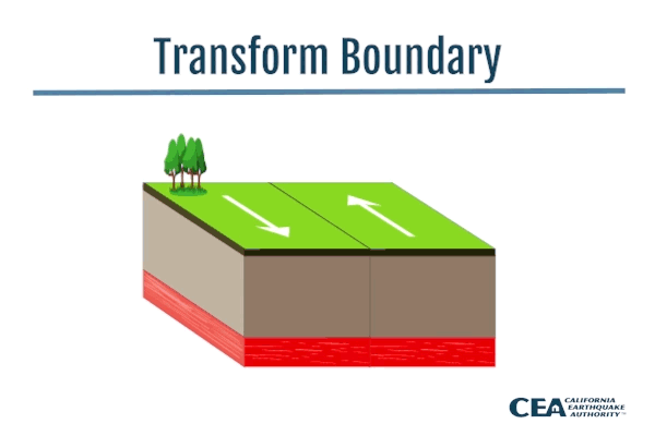
What plate boundary is the Ring of Fire on?
National Geographic explains that a transform boundary is formed when tectonic plates slide horizontally past each other. Parts of these plates get stuck at the places where they touch, causing stress to build up and rocks to break or slip, which ultimately cause earthquakes. These areas of breakage or slippage are called faults. Many of Earth’s faults are found along transform boundaries in the Ring of Fire.
The San Andreas fault, stretching along the central coast of California, is one of the most active faults in the Pacific Ring of Fire, which itself lies on the transform plate boundary between the North American Plate, which is moving south, and the Pacific Plate, which is moving north.
How did the Ring of Fire form?
According to National Geographic, the Pacific Ring of Fire’s formation is the result of plate tectonics. It is formed by the movement of these tectonic plates, which are huge slabs of the Earth’s crust that fit together like pieces of a puzzle. The article explains that plates are constantly moving atop a layer of solid and molten rock, known as mantle. Most tectonic activity in the Pacific Ring of Fire occurs in areas where the plates collide, move apart, or slide next to each other. This explains what causes the Ring of Fire.
Volcanoes along the Ring of Fire in the Pacific are formed, according to National Geographic, when one plate tectonic is shoved under another through a process called subduction. The Ring of Fire was formed by the development of several of these subduction zones and has existed for millions of years.
Why is it called the Pacific Ring of Fire?
The origin of its fiery name is rather simple. Think of it as a ring or a loop of 75 percent of the world’s volcanoes, which lie around the Pacific Ocean. National Geographic points out that the Pacific Ring of Fire is not entirely a circular ring, but is shaped more like a 25,000-mile-long horseshoe.
Why is the Ring of Fire important?
Besides the fact that the Pacific Ring of Fire is at the center of most seismic and volcanic activity in the world, it also is home to the deepest trench in the world. Because of its array of geological characteristics and formations, the Pacific Ring of Fire plays an important role in helping geologists and scientists better understand earthquakes, tectonic plates, and active volcanoes.
How many volcanoes are in the Ring of Fire?
NOAA estimates there are more than 450 volcanoes spread out across the Pacific Ring of Fire, which represent a large percentage of the of world’s volcanic activity. These Ring of Fire volcanoes stretch from the southern tip of South America, up along the coast of North America, across the Bering Strait, down through Japan and into New Zealand.
What are notable volcanoes in the Ring of Fire?
There are many notable Ring of Fire volcanoes. They include the Andes Mountains in South America; Japan’s tallest and most well-known mountain, Mount Fuji; Mount St. Helens in Washington State; Alaska’s Aleutian Island; Krakato, an island volcano in Indonesia; and Mount Ruapehu in New Zealand.
What is the most dangerous volcano in the Ring of Fire?
Volcanologist Heather Handley in a news article listed five Pacific Ring of Fire active volcanoes as the most dangerous. According to Handley, they are Mount Agung and Mount Sinabung in Indonesia, Mount Mayon in the Philippines, Mount Cadovar in Papua New Guinea, and Mount Kusatu-Shirane in Japan.
Why do earthquakes often happen around the Ring of Fire?
The simple answer is because of its massive size in the Pacific Ocean and because there is so much seismic activity in and around the Ring of Fire. For these reasons, most of the world’s earthquakes, including a majority of the world’s strongest shakers, occur in the Ring of Fire. The Ring of Fire’s hundreds of volcanoes forms a dangerous presence in the vicinity of several major plate tectonics. Because of these geologic characteristics, the Ring of Fire is under constant tension and threat of earthquakes, according to Britannica.
How many earthquakes occur in the Ring of Fire?
It is estimated that 90 percent of the world’s earthquakes can be labeled Ring of Fire earthquakes and 75 percent of the world’s volcanoes can be labeled Ring of Fire volcanoes, as they have occurred in or near the Ring of Fire.
Ring of Fire earthquakes and volcanoes have resulted in some of the worst natural disasters in recorded history, such as the 1960 Chile Earthquake, the 2004 Indian Ocean tsunami, the Japan earthquake of 2011, and the 1883 Krakatoa volcanic eruption. All four of these disasters had their origins along the tectonic boundaries of the Ring of Fire.

How to prepare for a Ring of Fire earthquake in California
Because of California’s proximity to the Pacific Ring of Fire and considering that the 800-mile-long San Andreas fault, one of the Ring of Fire’s most active faults, cuts across such a wide swath of the Golden State from Southern California to the San Francisco/Bay Area, it is extremely important for Californians to be prepared when the next major temblor occurs.
Especially vulnerable are those Californians living in homes built before 1980 that have not been seismically retrofitted to withstand the damage caused by the shaking from a major earthquake. For more information about making your home more resistant to earthquake damage and how to better protect both your home and your family when the next major shaker strikes, check out Strengthen My House.