Retrofit Basics
A. California has a greater than 99% risk of one or more devastating earthquakes striking the state in the next three decades*. With the heightened risk of earthquakes in California, all of us wherever we live in the state must begin to prepare for the personal and economic impacts of a major earthquake. Local businesses, housing, utilities and your home insurance are likely to be affected. It makes sense to understand the economic benefits of retrofitting your home to withstand earthquakes.
*According to the third Uniform California Earthquake Rupture Forecast (UCERF3) report.
A. Seismic retrofitting of vulnerable homes is critical to reducing your risk of earthquake injury and damage. The frames of older houses are often not bolted to their foundations, and if a cripple wall exists it may lack bracing. Houses without adequate bolting and bracing can slide or topple off their foundation during an earthquake.
Houses with a living space over a garage, and built before 2000, and before current building codes were in place may be vulnerable and not able to withstand the shaking of a damaging earthquake. The vulnerability is caused by the large open space and wall openings on the lowest floor. These conditions mean hatt there are fewer solid walls at the garage level, and walls are the structural elements that resist earthquake forces.
A code-compliant seismic retrofit can strengthen a house and may be critical to reducing your risk of earthquake injury and damage.
A. Interactive hazard maps are available from the California Governor's Office of Emergency Services ("Cal OES") on its 'My Hazards Awareness Map' website. Go to myhazards.caloes.ca.gov and click on the Earthquake tab. This website provides general information on earthquake hazards. By entering your address into the map search field at the top of the page and hitting 'Map Search,' a screen will appear with your address located on a map showing your local earthquake hazard. The page will also include a written description of earthquake hazards in your area.
A. There is no such thing as an earthquake-proof structure. There are measures that can be taken that will likely reduce the potential for or severity of earthquake damage.
Seismic retrofitting is the adjustment of existing structures to make them more resistant to earthquake activity, ground motion, or soil failure.
Consult the California Existing Building Code (CEBC) retrofit provisions. The code sets "minimum standards intended to improve the seismic performance of residential buildings; however, they will not necessarily prevent earthquake damage."
A. Identifying your house’s age, construction and foundation type is the first step in the earthquake retrofit process.
A visual inspection by a licensed contractor, engineer or architect can determine your home’s earthquake vulnerabilities. Recommendations from the licensed professional may suggest strengthening the connections between the house and the foundation, as well as strengthening the sub-area supporting walls.
Knowing what to do, where to do it, and how to do it are very important.
A. It depends on the type of house, the type of retrofit, and the scope of work.
On average, the construction work for an Earthquake Brace + Bolt retrofit often takes only 1-3 days. In almost all cases, the work does not require entry to the inside of your home. The construction work for an Earthquake Soft-Story (ESS) retrofit may take two to three weeks. If additional work needs to be completed to support the retrofit, the project could take more time to complete. Examples of additional work include, but are not limited to, buried utilities in inconvenient locations, shelving that would have to be removed and replaced, finishes that would need to be restored, etc.
A. We recommend looking at our Resources page for information from partner organizations and to get started. You can also check out information and tips from these websites:
- Association of Bay Area Governments Earthquake Resilience Program
- EarthquakeSafety.com: Retrofitting
- California State Treasurer: CAL/CAP Seismic Safety Financing Program
- California Seismic Safety Commission: A Homeowner’s Guide to Earthquake Safety 2020
- City of San Jose: Earthquake Retrofit Your Home
- Earthquake Country: How to Hire Someone to Strengthen Your Home
- California State License Board: Ten Tips
Earthquake Soft-Story (ESS) Retrofit Program
A. The Earthquake Soft-Story (ESS) program provides participants who own and occupy a qualifying house with a soft-story vulnerability (a living space built over a garage), and who qualify for the ESS program, an incentive grant to reimburse up to 75% of the total cost of the retrofit, up to $13k to assist in obtaining a seismic retrofit performed in accordance with FEMA P-1100.
A. An ESS seismic retrofit strengthens an older house (pre-2000), making it more resistant to earthquake damage caused by ground shaking and soil failure. The seismic retrofitting required for ESS is performed in accordance with FEMA P-1100 (seismic retrofit construction plan set) and directly addresses the vulnerabilities by:
- Strengthening the walls at the garage door or any other large openings with plywood or other strengthening elements including steel columns or proprietary shear elements;
- Bracing the perimeter walls of the lowest story and, if there is a crawl space, the cripple walls must also be braced; and
- Bolting the house to its foundation.
The ESS retrofit may require new reinforced concrete foundations at some or all of the existing perimeter and interior bearing walls. Strengthening the garage door may involve installation of steel columns or proprietary shear elements.
A. There may be instances when an engineer will need to be consulted. However, the ESS program provides the use of FEMA P-1100 plan sets for compliant soft-story retrofit work, in many cases, without requiring input from an engineer or architect. Contractors should first determine if the FEMA P-1100 plan set can be used to seismically retrofit a house before seeking an engineered solution.
A. For properties located in a FEMA-designated Special Flood Hazard Area (SFHA), receiving a FEMA-funded earthquake retrofit grant of $5,000 or more, FEMA requires compliance with the National Flood Insurance Program regulations. Because CRMP's Earthquake Soft-Story (ESS) grants, and some Earthquake Brace + Bolt (EBB) grants are FEMA-funded grants, affected program participants must comply with these regulations.
To comply with these FEMA regulations, EBB and ESS grant recipients, when the grant amount is $5,000 or more and their house is located in a SFHA, must maintain flood insurance on the property and provide proof of coverage to CRMP. Additionally, grant recipients must complete, notarize, and record the “Acknowledgement of Conditions for Mitigation of Property in a Special Flood Hazard Area with FEMA Grant Funds” Form.
- SPECIAL FLOOD HAZARD AREA CONDITIONS FORM (fillable PDF)
The completed Form must be:
- Notarized by a notary of the homeowner's choosing;
- Recorded with the applicable County Recording Office; and,
- Proof of the recorded document must be uploaded to CRMP through the Homeowner Dashboard to receive authorization to proceed with a retrofit and to receive grant funding.
A. FEMA P-1100 is a prescriptive, pre-engineered set of plans that can be adapted to retrofit crawlspace dwelling cripple walls, living space over garage dwelling, and ground story bracing walls.
A. The prescriptive provision or plan set is a "blueprint" version of a prescriptive ("cookbook") standard for strengthening homes to better withstand earthquake shaking. When approved by the local building official, the plan set may be used to strengthen older homes without the need for costly site-specific plans and design calculations. This plan set provides a low-cost method to help improve an older home's chances of surviving an earthquake. FEMA P-1100 is an example of a prescriptive standard.
A. LSOG stands for Living Space Over Garage but also may be designated as House Over Garage (HOG). Vulnerability in a LSOG house is caused by a significant reduction in the number of walls at the garage floor level due to an open space and wall openings on the lowest floor.
A. Your house may still be eligible to participate in the ESS program if:
- it is determined that your house is compliant with Eligibility Criteria 1 thru 5 from Table 5.1-1 of the FEMA P-1100 Prestandard (pg. 86), but is not compliant with one or more of the criteria from Table 5.1-2;
- it is determined that your house is compliant with Eligibility Criteria 1 thru 6 of “Table 1: Eligibility for Use” from Sheet S0 of FEMA P-1100 2A but is not compliant with one or more of the criteria 7 thru 15;
- it is determined that your house is compliant with Eligibility Criteria 1 thru 5 of “Table 1: Eligibility for Use” from Sheet S0 of FEMA P-1100 2B but is not compliant with one or more of the criteria 6 thru 13.
For any non-compliant issue mentioned above, a Registered Design Professional must address the non-compliant issues in accordance with P-1100 FEMA Prestandard, Section 4.5, Differing Conditions.
A. This is a pilot program and at present, we do not have a schedule of planned expansions. Program locations and ZIP Codes will be posted on the website. To receive updates about the program, please sign up for the mailing list.
A. The cost of a retrofit depends on many factors. It has been estimated that the cost of a soft-story retrofit of a single-family home may cost between $15,000 and $28,000, however, there are factors which could cause the cost to be significantly higher. An example of a factor that could cause costs to be significantly higher is the need for foundation modifications.
The ESS grant program will reimburse up to 75% of the total retrofit cost up to $13,000 depending on the house type. Please see Program Rules for more details.
A. No, the ESS program does not cover any work done on chimneys; however, FEMA P-1100 does have a volume addressing chimneys, and you may find some helpful information from Earthquake County Alliance, which addresses how to repair damaged chimneys and what to do to minimize future damage and risk.
A. Homeowners who have already completed a soft-story retrofit of their garage cannot participate in the ESS program. However, homeowners who have not completed a soft-story retrofit of their garage, but who have completed a 2019 CEBC Chapter A3-compliant crawlspace retrofit or successfully completed the EBB program, may participate in ESS.
A. CRMP’s ESS program does not allow a do-it-yourselfer to do their own retrofit. It must be done by a contractor listed on CRMP’s Contractor Directory.
CRMP’s EBB program allows for experienced owner/builders to do their own retrofit. The value of labor provided by an owner-builder is not a reimbursable cost under the EBB Program and is not considered a reimbursable out-of- pocket expense.
Knowing what to do, where to do it, and how to do it are important. A good plan is the place to begin. Often DIY homeowners choose to undertake some of the preparation and follow-up work themselves to save some money.
The details of solving tricky situations under a house are not covered in most do-it-yourself manuals. Making sure certain details are handled properly often makes a big difference in the strength of the retrofit. Prior to the installation of a retrofit, a good plan is needed. Prescriptive Plan Sets are available for certain types of houses.
For a raised foundation property, a seismic retrofit involves bolting or bolting and bracing the house to its foundation in compliance with California Existing Building Code Chapter A3. Remember, most foundation repairs require a building permit and plans to start work.
- City of San Leandro has an earthquake strengthening program with valuable DIY handbooks and tools.
- Association of Bay Area Governments (ABAG) standard plan for retrofits is available for San Francisco Bay Area residents.
- The City and County of Los Angeles and many of its surrounding cities accept the LA Standard Plan Set #1. Download them on our Resources page.
Other types of retrofits, such as post-and-pier or hillside houses require an engineered retrofit and may be too complicated for a do-it-yourselfer to complete.
A. ESS does not currently require initial inspections to participate in the program. To find out if your house qualifies, you can contact one of the contractors on the Contractor Directory. These contractors have completed the FEMA training for seismic rehabilitation of single-family dwellings. Contractors typically provide this service as part of an estimate for the project.
The Earthquake Brace + Bolt Program
A. In an Earthquake Brace + Bolt (EBB) seismic retrofit, the foundation is "bolted" to the frame of the house, and when there are walls called "cripple walls" in the crawl space under the house, they are "braced" with plywood. This helps prevent the house from sliding or toppling off of its foundation during an earthquake. An EBB seismic retrofit is only done on wood-framed, pre-1980 homes with a raised foundation.
EBB program registration is open for a limited time each year. When open, you can complete the registration form online. You will be asked questions about your house, and your answers will determine if your home qualifies for an EBB retrofit grant.
A. The Earthquake Brace + Bolt program was created by the California Residential Mitigation Program (CRMP). Earthquake Brace + Bolt offers up to $3,000 for homeowners to seismically retrofit their houses. To be considered for participation in the program once registration opens, homeowners must meet certain qualification requirements and register.
A. We do not have a schedule of planned expansions, but program locations and ZIP Codes will be posted on the website. You can also sign up to receive CRMP program update emails.
A. The cost of a retrofit depends on the type of construction, size, and location of the house, and the cost of materials and labor. The typical cost range for an EBB retrofit is between $3,000 and $7,000. Learn more about Earthquake Brace + Bolt retrofits.
A. The program is presently funded with contributions from the California Earthquake Authority's Loss Mitigation Fund and with money from the FEMA Hazard Mitigation Grant Program (HMGP).
A. If you are a Supplemental Grant recipient and you are in a Special Flood Hazard Area, and if your EBB grant is $5,000 or more and funded by a FEMA grant, you will be required to submit a signed and notarized form attesting that you will adhere to the FEMA requirements before any EBB incentive payment will be paid.
The form, which will be provided to you, will state that you will abide by and you understand the following:
- Flood insurance must be maintained for the life of the structure
- Insurance coverage on the property must be maintained during the life of the property regardless of transfer of ownership of such property.
- All structures on the property will be maintained in accordance with flood plain management criteria.
- I, as the property owner, must legally record, with the county or appropriate jurisdiction’s land records, a notice that includes the name of the current property owner and a legal description of the property and states the following:
“This property has received Federal hazard mitigation assistance. Federal law requires that flood insurance coverage on this property must be maintained during the life of the property regardless of transfer of ownership of such property. Pursuant to 42 U.S.C. §5154a, failure to maintain flood insurance on this property may prohibit the owner from receiving Federal disaster assistance with respect to this property in the event of a flood disaster. The Property Owner is also required to maintain this property in accordance with the flood plain management criteria of Title 44 of the Code of Federal Regulations Part 60.3 and City/County Ordinance.”
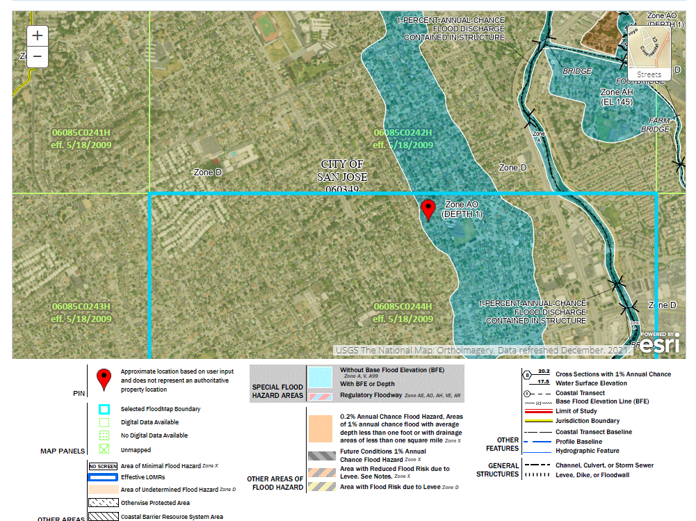
A. Visit the FEMA Flood Map Service Center and enter your address to see if your house is in a SFHA. If your address is in a blue colored area (example below), your house is in a SFHA.
A. EBB ZIP Codes are selected using the protocol criteria approved by the CRMP Governing Board. All California ZIP Codes were ordered by the following two criteria which were weighted equally:
- Earthquake Hazard: Hazard was identified using the United States Geological Survey (USGS) earthquake hazard map for California.
- Earthquake Vulnerability: Vulnerability was represented by identifying the percentage of pre-1940 houses in ZIP Codes in California (US Census Data). Older houses are more likely to require earthquake bracing and bolting.
As of January 15, 2025, EBB will be in over 1,100 high hazard ZIP Codes throughout California.
A. No. EBB does not cover any work done on chimneys; however, there are things you can do to repair damaged chimneys and minimize future damage and risk.
A. EBB provides up to $3,000 toward a code-compliant seismic retrofit to a qualifying house. Additional supplemental grant money is available to qualifying income-eligible homeowners. These Supplemental Grants may pay up to 100 percent of the cost of the retrofit as long as funds are available.
A. EBB is not currently requiring initial inspections for the program. To find out if your house qualifies you can contact one of the contractors on the Contractor Directory. The contractors on the list have taken the FEMA training for seismic rehabilitation of single family dwellings. Contractors typically provide this service for free as part of an estimate for the project.
A. EBB is also offering a Supplemental Grant to help income-eligible households pay up to 100% of the cost to seismically retrofit their homes. An “income-eligible household” is defined as a household with income at or below . These grants are based on available funds.
A. You may qualify for the Supplemental Grant if:
- Your annual household income is or less;
- You indicated during registration that you meet the income eligibility requirements;
- You are accepted into the EBB program;
- You are selected on a first-come, first-served basis to participate based on available funds;
- You submit the Income Verification Form (IVF) provided by EBB within 30 days of acceptance into the EBB Program; and
- The EBB verifies your income with the IRS.
A. You'll be asked to complete a short list of questions about your house, such as when it was built, and if it has a crawl space. See the complete list of EBB Qualification Questions.
Retrofit Costs, Grants and Tax Assistance
A: There isn't a standard cost for earthquake retrofitting a home. The retrofitting repair range for a brace and bolt type of retrofit runs from $3,000 to $7,000. Larger homes, those built on hillsides, and those with basements or rooms over garages will typically cost more to retrofit. But some houses may only require a "bolt only" retrofit, which costs about $3,000. The California Residential Mitigation Program (CRMP) provides grants to help you pay for a brace + bolt retrofit and an earthquake soft-story retrofit.
A. CRMP's grant programs, Earthquake Brace + Bolt (EBB) and Earthquake Soft-Story (ESS) offer grants to eligible homeowners. EBB also has a Supplemental Grant (SG) for income eligible homeowners (not available for ESS).
- Property Assessed Clean Energy (PACE) financing, offered in cities such as Berkeley, which allows property owners to borrow money to pay seismic retrofits and spread the cost of the upgrade over a period of time through a special assessment on their property tax bill.
- Low-income and fixed income residents of the San Francisco Bay Area may be eligible for grants specifically designated for home earthquake strengthening through the U.S. Department of Housing and Urban Development's block grant program. For more information, call (510) 577-6004.
- For recently-purchased homes, there are transfer tax Rebates: The cities of Berkeley and El Cerrito offer rebates or refunds on a percentage of your home’s transfer tax if you complete a voluntary seismic retrofit of your residential property.
A. No, FEMA funded CRMP grants, including EBB (Earthquake Brace + Bolt), EBB Supplemental grants, and ESS (Earthquake Soft-Story) grants, are not taxable at the state level in California, or at the federal level. The California Franchise Tax Board aligns with federal rules and excludes disaster mitigation payments from state taxable income.
A. For additional information, you can refer to:
- Federal Tax Rules: IRS Section 139 - Disaster Mitigation Payments
- California Tax Rules: California Franchise Tax Board - Disaster Relief
If you have further questions, consult a tax professional to understand how these rules apply to your specific situation.
Understanding House Types and Retrofit Terms
A. How your house is built and its foundation type determine what type of retrofit your house needs. Houses with a raised concrete perimeter foundation that lack sill plate anchors and/or crawl space walls (cripple walls) bracing may follow existing state building code (CEBC, Chapter A3) or standard plan sets, which also provide step-by-step directions. Download plan sets on our Resources page. You can also learn more about ways to strengthen your house.
A. It means that the framing of the house’s first floor is composed of beams and cross-beams made of wood. You should be able to look under the house to see if wooden beams and cross-beams support the first floor.
A. A cripple wall is a less-than-full-height wall between the house foundation and the base of the first floor of the house.
A. A continuous perimeter foundation is typically concrete and continuous under the exterior walls of a dwelling. Partial perimeter foundations or unreinforced masonry need to be evaluated by a design professional.
A. A slab-on-grade-foundation house has no basement or crawl space and therefore no basement wall. Your house is built on a solid slab of concrete.
A. A low-slope building site has a natural slope of 10% or less. If columns or beams support a house, it’s likely the house has been built on a slope greater than 10%.
About The California Residential Mitigation Program (CRMP)
A. No, CRMP is a joint powers authority formed by the California Earthquake Authority (CEA) and the Governor's Office of Emergency Services (Cal OES) through a Joint Exercise of Powers Agreement (JPA). CRMP is a separate legal entity, and it is not a state agency.
A. The program is presently funded with contributions from the California Earthquake Authority's Loss Mitigation Fund and with money from the FEMA Hazard Mitigation Grant Program (HMGP).
A. First check to see if your ZIP Code is included in one of our retrofit grant programs. If your ZIP Code is eligible, when registration is open, register to participate and answer the qualification questions to see if your house qualifies. If your house qualifies, complete the registration process. After your registration application is complete, you will be added to our list of eligible participants. Grant program recipients are then chosen by random selection and are notified by email when they are accepted to begin the retrofit process, and can submit their pre-retrofit documents. To remain eligible for the grant, participants may NOT begin any retrofit construction work until they have submitted all pre-retrofit documentation and received written approval from CRMP to proceed.
A. Homeowners will be notified by email if they are selected to participate in one of CRMP's retrofit programs. Notices will be sent when the selection process for the program for which you have registered has been completed. Learn more about the steps you'll need to take once you are accepted.
FEMA Special Flood Hazard Area Requirements
A. A Special Flood Hazard Area (SFHA) is an area having special flood, mudflow or flood-related erosion hazards and is shown on a Flood Hazard Boundary Map (FHBM) or a Flood Insurance Rate Map (FIRM) Zone A, AO, A1-A30, AE, A99, AH, AR, AR/A, AR/AE, AR/AH, AR/AO, AR/A1-A30, V1-V30, VE or V. The SFHA is the area where the National Flood Insurance Program’s (NFIP’s) floodplain management regulations must be enforced and the area where mandatory purchase of flood insurance applies.
A. The Federal Emergency Management Agency (FEMA) Flood Map Service Center (MSC) is the official public source for flood hazard information produced in support of the National Flood Insurance Program (NFIP).
You can visit FEMA’s Flood Map Service Center online to search by your property address to determine if your home is located in a SFHA.
A. For properties located in a FEMA-designated Special Flood Hazard Area (SFHA), receiving a FEMA-funded earthquake retrofit grant of $5,000 or more, FEMA requires compliance with the National Flood Insurance Program regulations. Because CRMP's Earthquake Soft-Story (ESS) grants, and some Earthquake Brace + Bolt (EBB) grants are FEMA-funded grants, affected program participants must comply with these regulations.
To comply with these FEMA regulations, EBB and ESS grant recipients, when the grant amount is $5,000 or more and their house is located in a SFHA, must maintain flood insurance on the property and provide proof of coverage to CRMP. Additionally, grant recipients must complete, notarize, and record the “Acknowledgement of Conditions for Mitigation of Property in a Special Flood Hazard Area with FEMA Grant Funds” Form.
- SPECIAL FLOOD HAZARD AREA CONDITIONS FORM (fillable PDF)
The completed Form must be:
- Notarized by a notary of the homeowner's choosing;
- Recorded with the applicable County Recording Office; and,
- Proof of the recorded document must be uploaded to CRMP through the Homeowner Dashboard to receive authorization to proceed with a retrofit and to receive grant funding.
A. The SFHA Acknowledgement of Conditions Form titled “Acknowledgement of Conditions for Mitigation of Property in a Special Flood Hazard Area with FEMA Grant Funds” is a fillable form that must be completed, notarized, recorded and submitted to CRMP to receive authorization to proceed with a residential earthquake retrofit. Homeowners can fill out the form electronically or print a blank form and fill it out.
NOTE: Do not sign the form until you are instructed to do so by a notary of your selection.
If you live in a Special Flood Hazard Area and have a mortgage on your home, you may already have flood insurance as a condition of your mortgage. Before receiving an ESS grant payment, you must provide a copy of your flood insurance policy to CRMP.
- SPECIAL FLOOD HAZARD AREA CONDITIONS FORM (fillable PDF)
Building Permits
A. A building permit is a certificate from the building department authorizing construction on a building or structure within their jurisdiction. According to the California Building Code, no building or structure shall be altered, repaired, or improved unless a separate permit for each building or structure has first been obtained from the building official.
A Your local building department may be managed by your city, town or county. To search for your local building department, go to the California Architects Board website. Contact your local building department prior to starting work to verify all local requirements.
A. Permit costs vary. Check with your local building department for costs and other requirements. The cost of the permit is a reimbursable expense in CRMP grant programs (please note that the EBB maximum grant amount is $3,000) after your retrofit work is completed, approved by the building department and all documentation has been submitted to, and approved by, CRMP. If you have been approved for the EBB Supplemental Grant, you can request immediate reimbursement for the building permit before your retrofit work is complete by submitting the receipt on your Homeowner Dashboard.
A. Building departments typically will allow a homeowner or their contractor to take out a permit. Homeowners who intend to act as an owner-builder should check with their building department for specific requirements.
A. You will need to identify the local building department that is responsible for issuing permits in your location. We recommend that you contact the building department in your jurisdiction for specific building permit requirements prior to commencing with any retrofit work. For a list of building departments, see the California Contractors State License Board website.
A. The building permit must include the following language under the proposed Scope of Work:
- For the Earthquake Soft-Story (ESS) retrofit permit: "Work is in general accordance with FEMA P-1100."
- For the Earthquake Brace + Bolt (EBB) retrofit permit: "Work is in general accordance with an accepted Standard Plan Set (i.e. Standard Plan Set A or Los Angeles Standard Plan Number One) or Chapter A3 or an engineered solution."
A. The type and number of inspections required by the building code official may vary from jurisdiction to jurisdiction. The building department will provide information about required inspections when the permit is issued. It is the responsibility of the owner-builder or contractor to schedule inspections with the building department and provide access for the inspector to review the work.
A. You should verify the requirements for sign-off on the building permit with your building code official. Typically, the work described in Chapter A3 and FEMA P-1100 requires one or more inspections by the building official. Verify the inspection requirements prior to starting the work.
Completing a Seismic Retrofit
A. Some of the retrofit provisions in Chapter A3 may be approved by a building code official without requiring plans or calculations prepared by a design professional (architect or engineer). Homeowners, contractors and design professionals should check with the local building code official to verify local requirements.
A. We recommend you learn how to protect yourself and what questions you should ask before hiring a contractor. This information is available from the Contractors State License Board.
A. The California State License Board provides online services that allow homeowners to verify information about contractors, including their license number and business name. The general contractor selected will need to have a license type A or B.
A. Check with your building department to verify what construction documents (drawings and other specifications) are required to obtain a permit. Some building departments may require a plan showing overall building dimensions and notes indicating where work will be performed. Chapter A3 includes retrofit details that may be referenced on the plan. Some building departments may have standard plan sets that the owner-builder or contractor can use. Please note that any modifications to the details in Chapter A3 must be designed by a registered design professional (architect or engineer).
A. Visit Earthquake Country Alliance for resources for strapping and bracing your water heater.
Troubleshooting
A. Typically, building inspectors issue a written documentation of items that do not pass inspection. It is the responsibility of the owner-builder or contractor to make revisions and have those revisions re-inspected by the building department. Please note that many building departments charge for re-inspections. Review inspection requirements and fees with your building department prior to starting construction.
Seismic Retrofit: Hiring a Contractor and DIY
A. It is common and accepted practice for seismic improvements to be planned by a licensed contractor, civil or structural engineer, or architect.
Many cities now have “prescriptive or standard plans,” which an experienced, licensed contractor or homeowner-builder can use in planning the retrofit. Engineered plans are advisable or may be required in the following situations:
- Large, complex, multilevel houses.
- Stilt houses on steep hillsides.
- Houses with large openings in lower level walls.
- Houses with serious foundation and/or drainage problems.
A. You may follow personal recommendations from friends and family, or consider online directories or paid advertisements. Search for licensed contractors in the Contractor Directory. Contractors on the CRMP Contractor Directory have completed FEMA trainings for EBB and ESS retrofits.
Before you make your final decision and sign a contract, the California Seismic Commission and the Contractor’s State License Board (CSLB) recommends:
- Getting at least three written bids on the project.
- Checking at least three customer references.
- Verifying the contractor's business location and telephone number.
- Ensuring the contractor has a license and the legally required bond.
- Verifying the contractor's workers’ compensation and commercial general liability insurance coverage.
A. The California State License Board provides online services that allow homeowners to verify information about contractors, including their license number and business name. The general contractor selected will need to have a license type A or B.
A. The California Seismic Safety Commission recommends that contractors be paid in installments as the work is completed. Other tips from the Commission include:
- Keep the down payment low. By law, a down payment on a home improvement contract cannot exceed 10% of the contract price or $1,000, whichever is less.
- Wait to pay the final bill until the local building department has signed off on the work and you have conducted a final review of the work to make sure it is complete and correct.
You can also check the California State Contractors State License Board(CSLB) for your contractor’s information and to verify they are licensed.
A. CRMP’s ESS program does not allow a do-it-yourselfer to do their own retrofit. It must be done by a contractor listed on CRMP’s Contractor Directory.
CRMP’s EBB program allows for experienced owner/builders to do their own retrofit. The value of labor provided by an owner-builder is not a reimbursable cost under the EBB Program and is not considered a reimbursable out-of- pocket expense.
Knowing what to do, where to do it, and how to do it are important. A good plan is the place to begin. Often DIY homeowners choose to undertake some of the preparation and follow-up work themselves to save some money.
The details of solving tricky situations under a house are not covered in most do-it-yourself manuals. Making sure certain details are handled properly often makes a big difference in the strength of the retrofit. Prior to the installation of a retrofit, a good plan is needed. Prescriptive Plan Sets are available for certain types of houses.
For a raised foundation property, a seismic retrofit involves bolting or bolting and bracing the house to its foundation in compliance with California Existing Building Code Chapter A3. Remember, most foundation repairs require a building permit and plans to start work.
- City of San Leandro has an earthquake strengthening program with valuable DIY handbooks and tools.
- Association of Bay Area Governments (ABAG) standard plan for retrofits is available for San Francisco Bay Area residents.
- The City and County of Los Angeles and many of its surrounding cities accept the LA Standard Plan Set #1. Download them on our Resources page.
Other types of retrofits, such as post-and-pier or hillside houses require an engineered retrofit and may be too complicated for a do-it-yourselfer to complete.
A. Because requirements vary, check with your local building inspection department to verify the construction documents and drawings required for a building permit. Many building departments accept standard plan sets, which the homeowner-builder or contractor can access online. If you hire a registered design professional (architect or engineer) to design a retrofit for your house with a crawl space walls (cripple walls), specify that they design the retrofit in accordance with Chapter A3 of the CEBC or one of the plan sets adopted by your local building official. Download plan sets on our Resources page.
A. There are standard sets of plans made available to homeowners and contractors by local governments, to use as construction documents for EBB and ESS seismic retrofits. These plan sets include specifications, details, and instructions. A registered design professional (architect or engineer) must design any modifications to plan-set provisions.
Visit our Resources page to download plan set PDFs.
A. Check with your local building inspection department to see if it has adopted a standard plan set that meets the requirements of the CEBC, Chapter A3 for EBB retrofits and FEMA P-1100 for ESS retrofits.
Download plan sets on our Resources page.